ORLANDO, Fla. – The first half of Tuesday will bring mostly sunny and dry conditions to Central Florida. However, stay weather-aware as showers and thunderstorms are expected to develop.
This evening, Florida’s typical summertime weather pattern kicks into high gear once again, with sea breeze collisions expected to fire up numerous showers and thunderstorms – especially along and just east of the I-4 corridor.
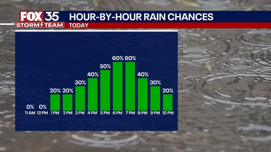
When will rain and storms arrive?
As the east and west coast sea breezes push inland throughout the afternoon, they’ll meet right over the I-4 corridor between about 4 PM and 7 PM, sparking off a line of storms set up right over the interstate.
These won’t necessarily be neatly organized; instead, expect random pop-up cells—some with heavy rain, gusty winds, and lightning – developing quickly and unpredictably.
Timeline:
From 2 p.m. to 5 p.m., showers and storms will appear near the coasts, with the core of storm energy peaking inland from 5 to 8 p.m., over cities like Orlando, Kissimmee, and Deltona.

What you can do:
If you’re heading out this evening, make sure you check in on the FOX 35 Storm Team app for your local radar and storm alerts, and the FOX Local app for LIVE forecasts from the FOX 35 Team.
Those apps can be found here.
FOX 35 Storm Tracker Radar
Track live when storms move across your area using the FOX 35 Storm Tracker Radar below.

Looking ahead :
The rest of the work week will bring daily rounds of afternoon showers and thunderstorms across Central Florida.
A cold front is expected to move through at the start of the weekend, increasing rain chances and bringing a slight drop in temperatures.
Saturday looks to be the wettest day, with the best chance for rain. However, as the front passes, rain and storm chances will decrease slightly for Sunday into Monday.
More radar maps from FOX 35 Storm Tracker Radar
STAY CONNECTED WITH FOX 35 ORLANDO:
The Source: This story was written based on information shared by the FOX 35 Storm Team on May 27, 2025.